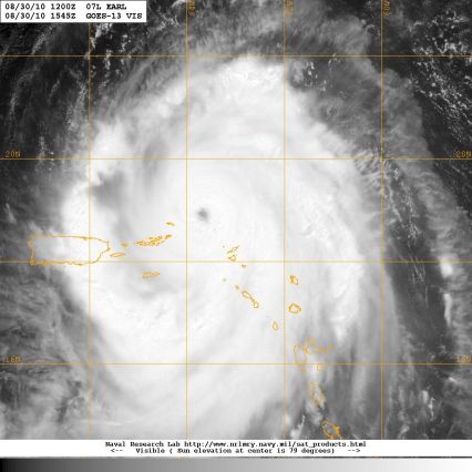
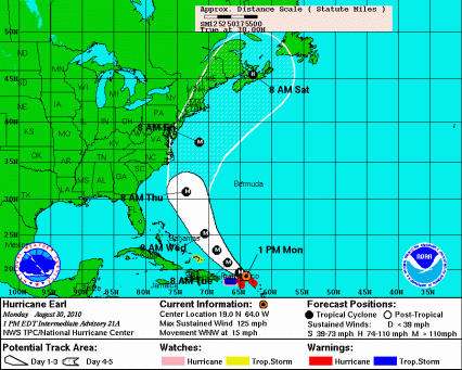
As of 1:00pm Monday, Hurricane Earl was about 75 miles northeast of St. Thomas in the Virgin Islands with winds topping out at 125 miles per hour. Hurricane force winds extend out 60 miles from the center of the storm.
The early afternoon National Weather Service Radar from Puerto Rico shows the rain bands of the storm radiating from the eye at the upper right edge (northeast quadrant) of the scan.
Over the past few days forecast models have indicated that the storm will turn northward and pass between Bermuda and the East Coast of the U.S. as a major hurricane with winds in excess of 110 mph.
The latest Hurricane Center forecast places the storm off the DELMARVA coast early Friday. Notice that the cone for the potential path of the storm center does include the DELMARVA Peninsula. All computer forecast models so far keep the storm center off shore at the end of the week but this is subject to change and it should be noted that each model run has pushed the storm track slightly farther west. This is a storm to be watched.
At the least, Mid Atlantic Beaches will likely see dangerous surf and breezy conditions. A few outer rain bands of the storm could affect beach areas Thursday night or Friday. At the most the storm could track farther west and be a much bigger problem.
East of Earl, a low pressure system is becoming better organized.
This system stands a very high chance of becoming a tropical depression or tropical storm. The name would be Fiona. This storm would also stand a chance of coming close to or striking the U.S. East Coast. If that were to happen, it would likely be some time next week.
August and September are the peak months for hurricane development. One reason for that is Atlantic water temperatures peak out at this time and warm ocean water is a primary fuel for hurricanes. The graphic below and accompanying text from the NOAA Environmental Vizualization Laboratory demonstrate and explain the process going on right now.
| Warm Oceans Intensifying Hurricane Season | |
| On the 5th anniversary of Hurricane Katrina’s landfall along the Gulf Coast (August 29,2005), tropical cyclone activity in the Atlantic is intensifying. Fueled by warm ocean temperatures, a series of consecutive storms have formed in the Intertropical Convergence Zone (the area between Africa and the Caribbean). Hurricanes Danielle and Earl have intensified into major hurricane strength (Category 3+), another system is following in Earl’s wake. The National Hurricane Center estimates a 90% chance that this system will intensify into a tropical storm. If so, it would be #6 of the season, named Fiona. And yet another storm system seems to be just behind.Using Tropical Cyclone Heat Potential data from NOAA/AOML, the amount of heat energy available to fuel hurricane intensification is plotted underneath a GOES-East image from 1445z. Earl is moving over an extremely warm area of ocean water and is expected to intensify as it moves northward along a path similar to Danielle. |
You can track these storms any time on the web by clicking http://www.wbaltv.com/hurricanes/index.html or by checking in with Tom, Tony, Sandra and me all week long on WBAL-TV 11.
John Collins


Guys , I realize that it is weather and could change at anytime , but it would be nice if you could give us a little more info or recomendations around the bay and ocean. A lot of us have properties and boats etc. that we need to start getting ready for the storm. It would be nice if someone there could take a stand and say – Looks like we are going to get hit or we do not think at this time that we are going to get hit. It just seems to me that John always wavers about the weather , instead of standing up and giving his forecast , like Bob Turke does. I love channel 11 but think that the weather could be better forecasted.